California!

Back in the home state, and on to the final stretch, we did a short hike in Tahoe: Eagle Falls near Emerald Bay.

https://www.flickr.com/photos/oruwu/19969197622/in/dateposted/

Normally the falls is overflowing and cascading down the rock face as a huge violent churning fall, but now due to the drought, it is merely a trickle:
https://www.flickr.com/photos/oruwu/19790381499/in/photostream/

We left Tahoe and headed home, and that’s it!

Last Long Drive Day

After arriving late in the evening at Jesse and Michelle’s place in Salt Lake City, we were greeted with a beautiful sunset. We were able to view it from Jesse’s roof, and could see the entire area.
https://www.flickr.com/photos/oruwu/19356328153/in/dateposted/

Jesse and Michelle, along with some local friends grilled up some burgers and traded adventure van ideas and wildlife encounters.

From Salt Lake City, we ended up driving straight through Nevada for 8+ hrs without any stops, and we arrived in Truckee in the evening to have dinner with Joanna’s parents and neighbors.

Trip Counter:
– Cumulative Caffeine Count: 34
– Puppy count: 4

Grand Teton Day 2

Our second day in grand teton started with a hike/jog 2 miles out to the tip of a peninsula in Colter Bay right at dawn to see the light on the magnificent peaks.
https://www.flickr.com/photos/oruwu/19329473563/in/album-72157652768606564/
First Light on the Tetons
https://www.flickr.com/photos/oruwu/19764600400/in/album-72157652768606564/

Much to Jo’s delight, this was the final night we were planning on sleeping in the tent (hooray, soft beds!), and so we packed up and headed out for another hike near Jenny Lake. Billed as the most popular hike, we went to see Hidden Falls and the Inspiration Point that stands above it. I guess at this point we should realize that the “most popular” hikes may not necessarily equate with the “best,” but it was still quite pretty despite the masses of people.

Hidden Falls
https://www.flickr.com/photos/oruwu/19353900694/in/dateposted/

https://www.flickr.com/photos/oruwu/19968650182/in/photostream/

Grand Teton was completely obscured by a cloud for the remainder of the day
Trail to the Tetons

Jo at Inspiration Point
https://www.flickr.com/photos/oruwu/19788629158/in/photostream/

Trip Counter:
– Cumulative Caffeine Count: 32
– Vistas skipped: 4
– Puppy Count: 6

One Big Park to Another

At Roosevelt Lodge we enjoyed a hot breakfast: Huckleberry Pancakes and a Western Egg Skillet. Then we packed up to get moving towards Grand Teton to the South.

Hayden Valley – lots of tourists out on the hillside waiting for a pack of wolves to come out of the forest on the far side of the meadow:
Hayden Valley

https://www.flickr.com/photos/oruwu/19762015199/in/photostream/

West Thumb has a small geothermal area where springs are actually in the lake.
https://www.flickr.com/photos/oruwu/19762487879/in/photostream/

https://www.flickr.com/photos/oruwu/19948756425/in/dateposted/

The first view of the Teton Range:
https://www.flickr.com/photos/oruwu/19941473982/in/dateposted/

Once in Grand Teton, we hiked to Hermitage Point

https://www.flickr.com/photos/oruwu/19924352716/in/photostream/

Wildlife was abundant on the hike – we saw Osprey, heron (pictured below), deer, beavers, and lots of smaller critters
https://www.flickr.com/photos/oruwu/19327871694/in/photostream/

Lots of spiky plants:
https://www.flickr.com/photos/oruwu/19762620558/in/photostream/

And to round out the evening, we visited the unfortunately lackluster lit Ox-Bow Bend, a famous photograph location.

Oxbow Sunset

Trip Counter:
– Cumulative Caffeine Count: 28
– Sly foxes: 4
– Puppy Count: 2

Yellowstone Touring

On the following day, we woke up at the crack of dawn to secure a first-come-first-served campsite at Tower Fall Campground near the Roosevelt Lodge. We got a great one as someone was packing up to leave, but more to come about this endeavor later…
Yellowstone gets it’s name from the canyon with the Upper and Lower Yellowstone Falls: the walls of the canyon burn a brilliant yellow, contrasted by the muted earthy tones, greens of the trees, and blue sky.

https://www.flickr.com/photos/oruwu/19899615555/in/album-72157652768606564/

Yellowstone Falls was spectacular with a plunge of over 300 meters, and dramatic yellow rock walls lining the grand canyon of Yellowstone.

Hiking around the North Rim:

Lower Yellowstone Falls:
Lower Yosemite Falls

The Grand Canyon of Yellowstone:
Grand Canyon of Yellowstone

The hike to fairy falls was a little disappointing. Marketed as the best hike in Yellowstone, and a beautiful trail to a spectacular waterfall, but were a little disappointed in a more or less flat hike through dense trees with no views, and a very thin waterfall that didn’t really impress after the grandiose Yellowstone Falls. The redeeming grace was a little offshoot trail that gave us a view of Grand Prismatic.

Fairy Fall:
https://www.flickr.com/photos/oruwu/19303988003/in/datetaken/

Grand Prismatic:
Prismatic Shore
Grand Prismatic Colors
Steam from Grand Prismatic
https://www.flickr.com/photos/oruwu/19302052994/in/datetaken/

A grizzly bear had traffic on the highway in a mess, and unfortunately we couldn’t stop, but we got this one image from the car:
https://www.flickr.com/photos/oruwu/19301716964/in/datetaken/

We walked around the Lower Geyser Basin, home to the famous Old Faithful. The geyser erupts every 90 minutes or so, and geologists are able to predict the time in a window of 20 minutes! Since we hung out for such a long time in the area and ended up eating our ‘very fancy’ instant ramen dinner in the lodge, we saw the geyser erupt 3 times!
Geyser Basin:

First time, right before sunset:
Old Faithful Eruption

The 2nd time:
Old Faithful at Dusk

And the third time was pitch black, so no photograph! After a long day of hiking around boardwalks and trails to fit in as much sight seeing as possible, we drove back to our campsite, only to discover that someone had stolen it… The campground being completely full, the perpetrators seem to have made an honest mistake in misreading our reservation tag at the site, nevertheless, this was severely annoying, especially since we had gotten up so early in order to secure it. We setup our tent anyways on a very not level area of the lot, and rested for another action packed day in Grand Teton.

Trip Counter:
– Cumulative Caffeine Count: 26
– Geyser eruptions: 3
– Campsites stolen from us: 1
– Puppy Count: 9

Journey into Yellowstone

From Bighorn Canyon we drove along slaloming between Wyoming and Montana, entering Yellowstone from the North and using the scenic Beartooth Mountain Pass Highway. Switchbacks ascent the hillside taking cars and motorcycles from dense forests to alpine mountain tops, along the ridgeline and back down into canyons and forests. It almost felt as if this highway allowed us to cheat and see miles of scenery only typically accessible elsewhere on foot after miles of exploration.

https://www.flickr.com/photos/oruwu/19710915680/in/photostream/

https://www.flickr.com/photos/oruwu/19891571642/in/dateposted/

Wildflowers were in bloom in varying degrees, depending on the location.

Alpine Daze

https://www.flickr.com/photos/oruwu/19277390873/in/dateposted/

Pilot & Index

Into the largest and first national park, our ‘to-do’ list just jumped an order of magnitude… geothermal springs, waterfalls, canyons, hikes, oh my! We drove through Lamar Valley, home to hundreds of Buffalo.
https://www.flickr.com/photos/oruwu/19710247268/in/dateposted/
Bison Roaming
As well as many other noble creatures, such as the pronghorn:

https://www.flickr.com/photos/oruwu/19710196930/in/dateposted/

On the night of our arrival, we visited Mammoth Hot Springs – a terraced network of colorful shelves, and bubbling springs, rising steam and white scorched dirt.

https://www.flickr.com/photos/oruwu/19899546405/in/dateposted/

Mammoth Springs Terraces

Sunset in the Terraces

Trip Counter:
– Cumulative Caffeine Count: 22
– Buffalo: 329
– Tourists breaking rules clearly stated on signs right next to them: 3
– Puppy Count: 3 (1 saved!)

Out of the Plains and into the Wild West

We left the Badlands and headed to Wyoming! On the way out, we saw lots of bighorn sheep!
https://www.flickr.com/photos/oruwu/19705787789/in/dateposted/
https://www.flickr.com/photos/oruwu/19897451831/in/dateposted/

Both of us found it interesting that technically we have entered the Old West, but there is still much more to the West of us (like California!). On our way, we stopped by Mount Rushmore. We were lucky we got there early because by the time we left, it was fairly crowded already. We enjoyed reading about the four presidents (Washington, Jefferson, Teddy Roosevelt, and Lincoln), and we got to learn a bit about the whole process of creating Mount Rushmore. The credit goes to Gutzon Borglum for envisioning the task, but ~400 workers were involved in the creation. Fortunately, nobody was hurt in the process. It is incredible to think of their endeavor, especially given the fact that Mount Rushmore was made from 1927-1941. We drove by an entrance for the Crazy Horse Monument (a work in progress), and the tools that they have now for a similar undertaking to Borglum’s include lasers and higher-tech drills (vs. the good old-fashioned dynamite and “honey-combing technique with hand drills). We weren’t quite sure what to expect with Mount Rushmore, but we were quite impressed!

https://www.flickr.com/photos/oruwu/19271414913/in/dateposted/

https://www.flickr.com/photos/oruwu/19704344620/in/dateposted/

From Mount Rushmore, we drove to Bighorn Canyon via Bighorn National Forest. It was a beautiful drive in such a different environment. It was hard to believe that we had just been driving in the plains! The temperature dropped considerably as we entered the forest, and the wildflowers were all abloom. The elevation gain gave us a good view point of South Dakota and Wyoming, and we saw the second highlight of our trip….MOOSE!! Neither of us have seen a live wild moose before, and we were very excited to just happen on TWO of them. The second one we saw we couldn’t capture in a photo, but it had giant antlers!! Bighorn National Forest was beautiful, and if anybody is driving through the area, we highly recommend taking the extra miles to drive through the forest.

https://www.flickr.com/photos/oruwu/19705804459/in/dateposted/

https://www.flickr.com/photos/oruwu/19271282363/in/dateposted/

https://www.flickr.com/photos/oruwu/19866102356/in/dateposted/

We arrived at our campsite in Bighorn Canyon Recreation Area shortly before sunset. We got some good viewpoints at Devil’s Overlook, and we had another animal sighting! This time, it was of a wild mustang!! The recreation area includes a wild horse sanctuary (the Pryor Mountain Wild Horse Range), and there are 120-140 wild horses that run free in the sanctuary. Apparently, genetic testing has tied them to colonial Spanish horse breeds or Spanish mustangs, which are considered a very rare breed. So we were very lucky we got to see even one!

Devil's Overlook Canyon Horseshoe Bend at Sunset

https://www.flickr.com/photos/oruwu/19271297393/in/dateposted/

Wild Mustang in Bighorn

Trip Counter:
– Cumulative Caffeine Count: 19
– Extra states not counted as states: 6
– Puppy Count: 14
– Turtles saved while crossing the road: 1

Badlands

We arrived in Badlands National Park in the mid-afternoon and were greeted with LOTS of humidity and heat. Ick. We even considered cutting our stay short because it was so hot! We decided to set up our camp and spent a lot of time at the air-conditioned visitor’s center learning about the Badlands. When it cooled down, we went to hike Notch Trail at sunset.

Notch Trail Canyon

This hike was one of the highlights of our trip so far, mostly because of the epic lightning storm + sunset that we saw. It was beautiful!! And there were so many lightning strikes off in the distance – nature’s very special light show.

https://www.flickr.com/photos/oruwu/19645953256/in/dateposted/

Joanna and Lightning

https://www.flickr.com/photos/oruwu/19723889205/in/dateposted/

Because our second day in the Badlands was supposed to be even hotter, we decided to get up at the crack of dawn to go for a hike. We caught sunrise at the Door and Window by the entrance to the park, and then embarked on the Castle Trail. The trails ended up being mostly along the meadows looking into the rock formations, but we were able to venture into some of the formations. Jo found a “mini-tree” trying to grow, but really it’s just some shrubbery.

2015-07-13 06.28.18

https://www.flickr.com/photos/oruwu/19716467912/in/dateposted/

More photos from the Badlands are posted on David’s flickr:
https://flic.kr/p/w4j21V

The Door Sunrise

We left the next morning, and encountered lots of wildlife on our way out of the park! We’ll cover them in the next post 🙂 It was very exciting – lots of first sightings for both of us! Porcupine says HIII!!!
https://www.flickr.com/photos/oruwu/19725102015/in/dateposted/

We also had some fun photo-taking time on the way out Badlands…
https://www.flickr.com/photos/oruwu/19729188681/in/dateposted/

https://www.flickr.com/photos/oruwu/19536755440/in/dateposted/

Yellow Mounds

Vista

Trip Counter:
– Cumulative Caffeine Count: 15
– Mosquito bite count, Joanna: 18
– Mosquito bite count, David: 3
– Temperature: 97
– Puppy Count: 10

Highway 90

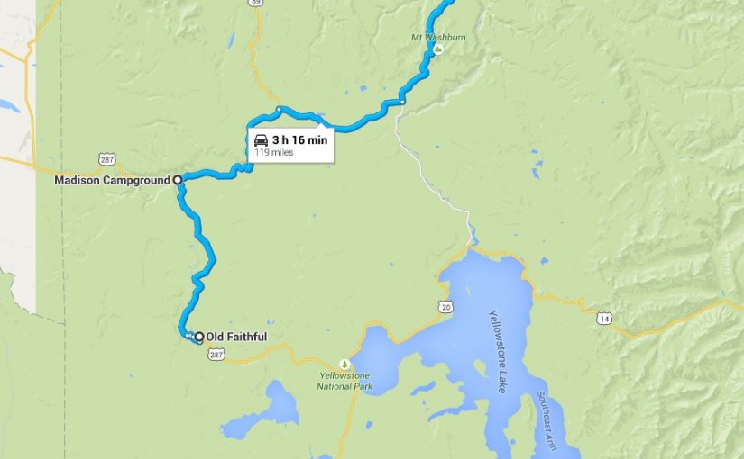
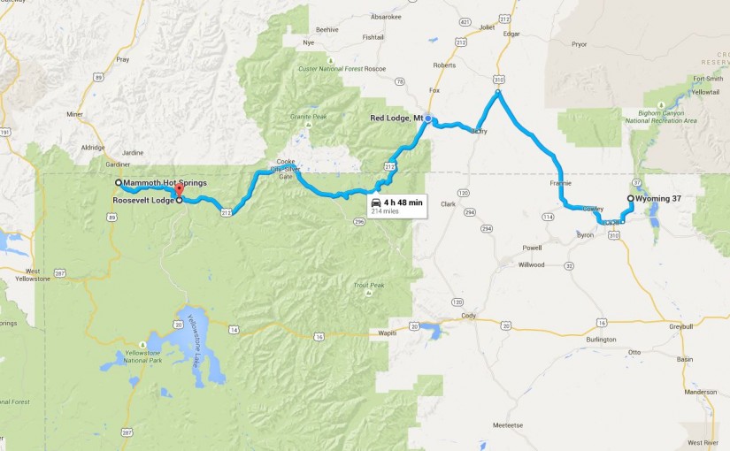
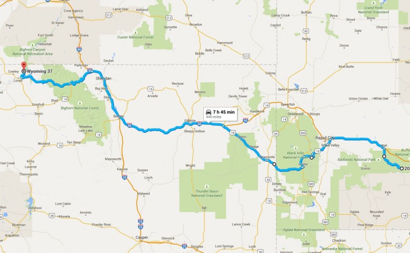
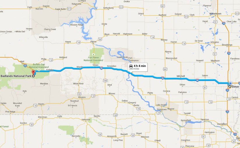
Speed limit – 80!!!! We drove through much of South Dakota today, from Sioux Falls to Badlands National Park. Along the way, we stopped at Al’s Oasis in Oacama and had a buffalo burger and stocked up for our camping meals. We don’t really have too much to say of the drive except that it is very flat and green. And there are lots of cows. So many cows (including some baby ones!) We also stopped by the Corn Palace. Both of us didn’t quite know what to expect with the Corn Palace – it is marketed as the only Corn Palace in the world, and I think we both envisioned something along the lines of having a corn maze, being made completely of corn, lots of tasty options involving corn, and interesting history and facts about the development and evolution of agricultural corn. Currently, the Corn Palace is in the tail end of a 1.5 year renovation, so we missed it in it’s complete and decorated glory. The murals were pretty and made of different types of corn, but the building was not made of corn and there was no maze. The metal turets on the ground and the dome that you see in the picture on the street are going to go up soon when all of the renovations are complete.

https://www.flickr.com/photos/oruwu/19050380273/in/dateposted/

The building doubles as a gym of some sort, so there was stadium seating as well (also, not made of corn). Jo could not resist taking a corny picture with the giant ear of corn.

2015-07-12 10.52.52

On our way to Badlands, we saw lots of billboards for Wall Drug. One of our friends recommended paying a visit to the world’s largest pharmacy as well, so we went to check out Wall Drug. The billboards are all correct! They have 5 cent coffee, a T-rex that dines every 15 minutes, and homemade ice cream and donuts. We were curious as to how Wall Drug got so big and well-known as a tourist destination. It all started when Mrs. Hustead thought that advertising for free ice water on the highway would entice visitors to stop by their pharmacy for a drink while driving to Mount Rushmore. Mr. Hustead thought it was a great idea, and soon the billboards took off and their business boomed! It gained world-wide recognition during WWII, when people in the U.S. military would take pictures with signs demarcating distance to Wall Drug. Apparently, there is a sign at the Taj Mahal indicating mileage to Wall Drug (according to the NY Times in 1999).

There are also lots of jackalopes at Wall Drug – if you don’t know what that is, it is a jack rabbit with antelope antlers. Ironically, what we know as jack rabbits and antelopes technically aren’t rabbits or antelopes. But a taxidermist found a rabbit with some antler-like growths (apparently as a result of the Shope Papilloma Virus…which I guess is the rabbit version of HPV?). According to myth (source: the tag of a jackalope stuffed animal), the jackalope was seen in the late 1800s by somebody and when he reported his sighting, nobody believed him. It is said that in the Old West, when cowboys serenaded their herds at night, they would hear the jackalope singing back at them in human voices (aka, an echo). David and Jo had some fun learning about jackalopes and racing them. If you can’t tell, Jo’s winning the race.

2015-07-13
https://www.flickr.com/photos/oruwu/19048821894/in/dateposted/

We also ate some tasty homemade ice cream at Wall Drug.

https://www.flickr.com/photos/oruwu/19483415840/in/dateposted/

Right before the entrance to Badlands, we stumbled across a prairie dog ranch. Of course, we had to stop! We got to observe the prairie dog ways and feed them unsalted peanuts (they were provided by the ranch). They seemed to also be very hot under the sun, as they would push some dirt aside and then belly flop. And then they used all of their energy to make the same call in a wave down the field of prairie dogs. They were pretty cute and chubby, and especially cute when they stood up and hung out outside of their tunnels. In reading up on prairie dogs, Jo learned that there are 5 different types of prairie dogs – prairie dogs are also known as American meerkats. Curious about the calls we were hearing, she watched this: https://www.youtube.com/watch?v=jcB5kySUxWA
Apparently, prairie dogs have the ability to identify and communicate species to each other, even going down to detail including height, size, and color that they’re wearing. Because the educational video on prairie dog language didn’t cover black-tailed prairie dogs, we are only left to assume that they were identifying us as weird tall hairless things with odd-shaped big orange heads. Also, apparently black-tailed prairie dogs are one of the two prairie dog types that do “jump-yips,” which is exactly what it sounds like. If you’re actually interested in learning about the alarm calls (Jo thought it was interesting enough to sit through 8 minutes of), here is the link: https://www.youtube.com/watch?v=y1kXCh496U0

https://www.flickr.com/photos/oruwu/19645063946/in/dateposted/

https://www.flickr.com/photos/oruwu/19048710564/in/dateposted/

Trip Counter:
– Cumulative Caffeine Count: 15
– Tanks: 4
– Toll: $36.35

Today Only:
Puppy count: 10
Llama count: one field. (~15)

A Long Day

Today was our longest day of driving. We went from Chicago to Sioux Falls – quite a difference in terms of city size! There was a lot of this…
2015-07-11 11.10.22

Also, Illinois toll is interesting in that they charge $1.50 every so often…so have some change ready! Along the way, we passed through Wisconsin and Minnesota. Both were beautiful and green, with lots of interesting clouds. And also lots of wind turbines!

https://www.flickr.com/photos/oruwu/19435620899/in/dateposted/

We finally arrived in Sioux Falls, and went to Falls Park to see the namesake falls. The park is very well-maintained and is nice to walk around, especially since it is a little bit cooler around the water. We were able to capture some of the orange-y colors during sunset on the red-pink quartzite. In terms of history, these falls were the site of a former mill (Queen Bee Mill House – 3rd picture), and the second picture shows the old water pipeline to the turbine and mill. The height differential allowed for more potential energy to be harnessed.

https://www.flickr.com/photos/oruwu/18999631254/in/dateposted/

https://www.flickr.com/photos/oruwu/19626598531/in/dateposted/

https://www.flickr.com/photos/oruwu/19596009716/in/dateposted/

Sunset at Sioux Falls

We then decided to explore some of downtown Sioux Falls.

2015-07-11 21.55.45

Some observations from our short stay in Sioux Falls – there are lots of motorcycles and loud cars, and the night life seems to be a pretty big thing on their main street. It seemed like there were more bars than restaurants, but Jo still managed to find something to satisfy her craving for something “light,” even if that meant going to a Japanese restaurant in the middle of land-locked America. (In her defense, we have been eating lots of heavy food and I think the deep-dish pizza may have been a bit too cheesy for our lactose-intolerant friend). There are also lots of statues and sculptures, including a very cute Ralph the Moose and a dog licking a child.

Trip Counter:
Trip Counter
– Caffeine Count: 14
– Toll: $36.35
– Tank: 3
– States – NY, NJ, MA, Ontario, MI, IN, IL, WI, MN, SD

Puppy count was low today given the amount of driving – we only came in at 10. But we got to play with this guy at a rest stop. He’s a border collie/german shepherd mix, from an Amish family.

2015-07-11 13.32.52